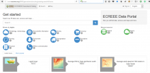
The ECOWREX Spatial Data Infrastructure is the section on the ECOWAS Observatory for Renewable Energy and Energy Efficiency (ECOWREX) that contains spatial data and applications for sustainable energy planning and data sharing.
Released recently by ECREEE, the ECOWREX SDI offers now ECOWREX users a platform to explore, visualize, extract, download and share geospatial information.
This 60 minutes webinar will introduce the ECOWREX SDI and its contents to potential stakeholders in charge of energy planning in ECOWAS member states. More specifically it will:
- Introduce the ECOWREX Spatial Data Infrastructure;
- Explore the map viewer user interface and tools;
- Explore the GIS maps and resources available on the map viewer;
- Analyze the sources of the information: explore the metadata catalog;
- Explain how to download geospatial information from the map viewer;
- Explain how to extract and share spatial information from the map viewer;
The participating stakeholders will learn how to use the ECOWREX SDI to visualize data, check the information associated to the GIS layers, explore the metadata, download information and share contents.
The presentation of 45 minutes will be followed by an interactive question and answer session of 15 minutes with the audience.
The webinar will be recorded. If you are not able to attend, but would like to view the recording, please register at the same link. We will send you a link to the recording following the event.
Speakers:
Daniel Paco, GIS Specialist, ECREEE.
Jafaru AbdulRahman, PO ICT, ECREEE.
Register for the webinar: https://attendee.gotowebinar.com/register/1519431993515579649


